

By Scott Crozier, Vice President, Civil Construction Field Systems, and Boris Skopljak, Vice President, Geospatial Sector
Disasters are as inevitable as they are devastatingly indiscriminate, but they’re not insurmountable. For government agencies, utility providers and other entities responsible for emergency preparedness and the management of critical assets such as roads and bridges, oil and gas pipelines, water and power infrastructure and even millions of acres of national parks, disaster recovery starts with preparation — and preparation hinges on reliable data and the technology to harness it.
Whether you live in a gated Los Angeles community, camp in Texas Hill Country, or worship in an 850-year-old Paris cathedral, in every corner of the world we are constantly reminded that nowhere and no one is immune from these events. Global insurance company Munich Re estimated that last year, natural disasters like Hurricane Helene caused losses of $320 billion worldwide. Through the first half of 2025, global losses from disasters like the Los Angeles wildfires have already reached approximately $131 billion, of which insured losses were the second highest in the first six months of any year over the last 45 years.
While the price of these disasters from both nature and negligence is increasingly calamitous, this pales in comparison to the true cost of these events—thousands of people around the world who lose their lives or livelihoods as a result every year.
From landslide monitoring to landmine mapping
When it comes to sound disaster preparation, the more we know, the faster we can respond and recover or better predict and prevent altogether. If an asset or area isn’t continuously mapped, monitored and measured, the potential for a relatively minor problem to cascade into a catastrophic event increases exponentially.
As more public agencies, private companies and nonprofits embrace predictive insights to understand where risks are greatest and finite budgets are most impactful, the details are in the data. Consistent mapping, monitoring and measuring provide a digital lens into displacement, deformation and other trends over time—how much a road has settled, a building has tilted or water level has risen—that can prevent damages, mitigate costs, spur faster response and recovery and, most importantly, save lives.
Landslide mitigation
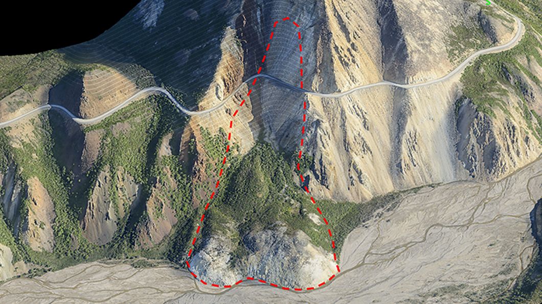
Take the National Parks Service, where a critical, high-elevation road in Alaska’s Denali National Park & Preserve was settling about 10 centimeters annually. With real-time monitoring the road can be immediately closed and repaired if slope stability reaches a specific threshold, mitigating a potential landslide that could endanger park visitors, staff and wildlife.
Evacuation mapping
Or the City of Detroit, which leverages mobile mapping technology (think Google Street View on demand) to consistently map the city’s approximately 140 square miles. Officials can ensure primary and secondary emergency routes remain viable and unobstructed and flag potential issues like road conditions or new construction that may delay or endanger citizens during an emergency.
Historic restoration
It isn’t just preparation though, it’s also preservation. At Notre-Dame Cathedral in Paris, 3D scanning and imaging technology helped provide a millimeter-level digital blueprint of the historic structure, contributing to the landmark’s precise and painstaking five-year restoration after it was gutted by fire in 2019.
Climate (and community) conservation
Thousands of miles away in Equatorial regions, Global Navigation Satellite System (GNSS) technology empowers scores of researchers and volunteers to map glacier ablation to within fractions of a centimeter straight from their tablets or smartphones. These same high-precision positioning solutions that power planet-saving research also enable life-saving work from humanitarian organizations like The HALO Trust to safely and reliably map landmines in remote conflict zones worldwide, a critical first step toward land reclamation and rehabilitation.
Turning data into disaster resilience
We're not so far away from AI systems being able to ingest swaths of reality capture and model data from a multitude of sources (i.e., Esri/GIS) and recommend everything from smarter evacuation routes to asset maintenance priorities based on available budget—performance that is entirely dependent on the quality of data that underpins them.
As more public and private customers clamor for insights to inform their disaster planning and postures, this data—how it’s captured, connected, stored and analyzed—is increasingly under the microscope. But when the stakes are this high, it goes far beyond poor data, poor insights. The consequences may not just be wasted dollars or misdirected assets, but destroyed communities or lives lost.
That’s why it’s paramount that quality data from the physical world informs the digital one, flowing seamlessly between field and office. As AI gives us a digital shot in the arm to look back further and faster at historical trends, query decades of data in natural language and gain deeper insights that lead to quicker, more precise warnings, trusted data is the bedrock that gives teams confidence these AI predictions and outputs are accurate.
We’re already seeing this in practice, where utility providers are leveraging AI-powered analysis of drone and mobile mapping data for fire prevention, recognizing different vegetation to predict how quickly it will encroach buffer zones around power infrastructure. Departments of Transportation are also relying on AI to analyze asphalt and paving conditions along thousands of miles of roadway for safer driving conditions, segmenting problematic stretches and feeding this information to machine control systems for more efficient repairs.
Pre-disaster preparedness, post-disaster response
Some disasters are preventable; others are simply unavoidable. In either case, data is the best tool in our kit to plan for them, prevent them, respond to them and, eventually, recover from them.
Investments in disaster resilience are investments in community well-being, with every dollar invested in disaster preparedness potentially saving $13 in damages, clean-up costs and economic impact. Teams that embrace technology to continuously map, monitor and measure their environments and harness this information will achieve greater resilience to meet the entire disaster lifecycle head on or anticipate it altogether—preserving assets, protecting communities and safeguarding the people who live within them.
Learn how Trimble solutions help customers manage disasters with speed, resilience and data-driven decision making, from planning and preparation to response and recovery.


