Skip to content
Three hikers smiling at a mountain summit selfie, wearing winter gear, with rocky peaks and a clear blue sky behind them.
Technologie

Taking measurement precision to new heights

2 Procès-verbal lu
| |
août 12, 2026

Partagez cet article :

Résumé

The “Trimble in the Wild" video highlights how millimeter-level precision—routinely relied on for construction and geospatial success—is redefining the list of Colorado’s highest peaks.

By Matt Sewick and Hannah Finch, Trimble Brand Team


Precise measurement and positioning are at the core of construction and GIS success, Trimble history and a new video settling a mountaineering debate.

Renowned climber and engineering Ph.D., Eric Gilbertson, Trimble CEO Rob Painter and a Trimble video crew scaled Colorado’s Mt. Elbert in June equipped with Trimble DA2 GNSS receivers. The first-ever satellite measurement of the tallest peak in the Centennial state, and second tallest in the contiguous United States, confirmed a summit elevation of 14,439.45 feet.

The next stop was the state’s Crestone and East Crestone Peaks. Gilbertson, who has climbed to the highest point in 153 countries, and the video crew this time carried Trimble R980 receivers. The goal was to measure the neighboring summits to settle which is taller and therefore qualifies as a “14er”.

For the uninitiated, “14ers” are independent mountains (how far climbers must descend before climbing an adjacent peak determines if they are “independent”) more than 14,000 feet above sea level. Colorado is home to 53 of them. Summitting them all is an established bucket-list challenge for climbers.

“Trimble in the Wild” chronicles the trip, explains why only one of the Crestone Peaks can be on the official “14er” list and reveals what the climbers found out. Partial spoiler alert: Trimble scanning technology confirmed a height difference of less than 5 inches.

Like Gilbertson and his Trimble companions, the GNSS systems were undeterred by challenging terrain and natural obstacles that could compromise results with older or less advanced options. The Trimble technology mitigates common threats to GNSS accuracy, including multipath, signal blockage and ionospheric disturbances. The millimeter-level precision to resolve the debate about peak heights gives construction and geospatial pros confidence to turn complex survey challenges into highly-accurate reality capture.
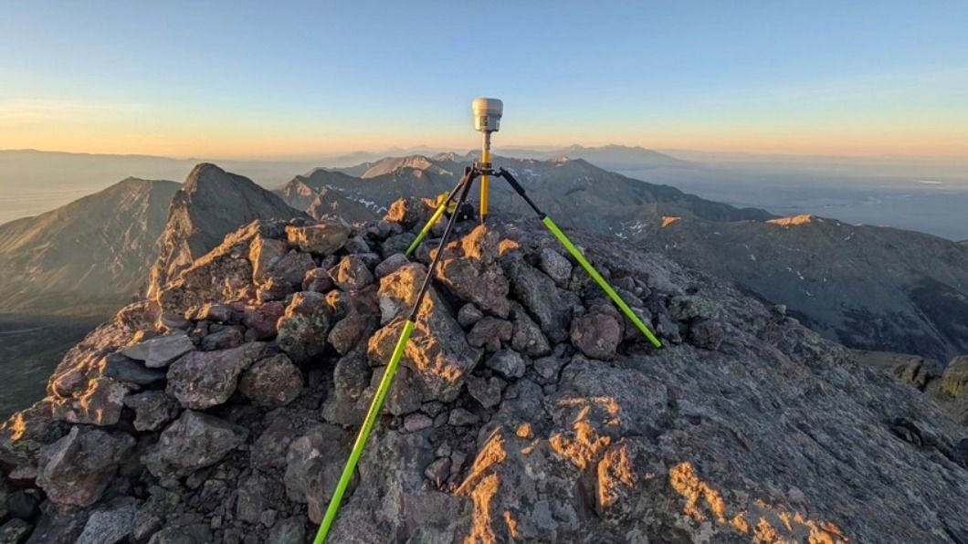
A GPS surveying instrument on a tripod sits atop a rocky mountain summit at sunrise with mountain ranges beyond.

Check out additional videos from the Trimble Everywhere You Turn road trip series.

Watch now

Attention

We tried to combine the products in your guest cart with your saved cart, but we encountered an issue while merging them. When choosing a subscription, please select either monthly or yearly as they cannot be combined. Kindly review your cart before proceeding to checkout.

Cart updated
Some items in your cart are not available for purchase in your region, so we removed them. Please review your cart before proceeding.

Items Removed:
Attention

Le logiciel que vous essayez d'acheter n'est pas disponible dans votre pays ou votre région.

Cart updated
The items in your cart have been updated for two reasons. Firstly, the prices now match the currency linked to your account address. Secondly, some items have been removed because they are not available for purchase in your region. Please review your cart before proceeding.

Items Removed:
Cart updated
The items in your cart have been updated for two reasons. Firstly, you've added too many of one item to your cart. Secondly, some items have been removed because they are not available for purchase in your region. Please review your cart before proceeding.

Items Removed:
Cart updated
The items in your cart have been updated for three reasons. Firstly, the prices now match the currency linked to your account address. Secondly, you've added too many of one item to your cart. Thirdly, some items have been removed because they are not available for purchase in your region. Please review your cart before proceeding

Items Removed:
Cart updated

Votre devise a été modifiée et correspond maintenant à la devise associée à l'adresse de votre compte.

Cart updated

Votre panier a été mis à jour pour deux raisons. Tout d'abord, les prix reflètent maintenant la devise liée à l'adresse de votre compte. De plus, vous aviez ajouté au panier un article en trop grande quantité. Vérifiez votre panier avant de poursuivre.

Cart updated

En combinant les produits de votre panier d'invité avec ceux de votre panier enregistré, vous avez dépassé la quantité maximale autorisée pour au moins un article. Vérifiez votre panier et rectifiez les quantités avant de passer au paiement.

Attention

We were unable to access your account information. Please contact customer support for assistance.

Attention
Impossible de mettre à jour les informations du panier d'achat. Veuillez actualiser la page pour résoudre le problème. Si le problème persiste, merci de Contactez l'assistance Trimble.
© 2026 Trimble Inc.

Trimble est une entreprise technologique internationale qui connecte le monde physique au monde numérique, transformant ainsi les méthodes de travail. Par son innovation constante dans le domaine du positionnement précis, de la modélisation et de l'analyse des données, Trimble est au service de secteurs essentiels tels que la construction, la technologie géospatiale et le transport. Qu'il s'agisse d'aider les clients à construire et à exploiter des infrastructures, à concevoir et à construire des bâtiments, à optimiser les chaînes d'approvisionnement mondiales ou à cartographier le monde, Trimble est à l'avant-garde, favorisant la productivité et le progrès.