By Bruce Jumper, Partner Advisor, Trimble. Co-Authored by Billy Lang, Product Manager, Trimble and Adam Carnow, Public Works Industry Marketing Specialist, Esri
As I reflect on my 15 years in the utility, state and local government markets, I sometimes think one could make an entire career out of this industry’s endless cycles of digital transformation. We talk about replacing legacy software, managing the loss of institutional knowledge as an experienced generation retires, and moving workflows from paper to digital. Sometimes it feels like these initiatives never actually end; they are just restarted by the relentless march of time and innovation.
Every local government agency is on its own unique digital journey, moving at its own pace. Today, there is no shortage of permitting solutions on the market that promise improved processes and operational efficiencies. If you are transitioning from physical paper or flat, static PDFs to a basic digital intake system, you will see a bump in productivity. Digital workflows route forms through departments faster, and public access portals give developers an easier way to check their application status.
These baseline efficiency gains, positive public sentiment and standard return on investment (ROI) are well-documented. But basic digitalization is no longer the finish line; it is merely the entry fee.
The constant in our industry is change. We will all ultimately be graded not by how well we digitized yesterday’s paperwork, but by how effectively we build a data foundation capable of leveraging the innovations of tomorrow. The next true evolution of the community development market isn't about electronic forms; it is about spatial data integrity and the location-based intelligence we can derive from it.
The villain of the story: The dark data of "address-centric" systems
In our previous co-authored article with Esri, “Thriving Communities Are Powered by GIS‑Enabled Permitting,” we established that permitting is a fundamentally location-based workflow. The geography of a project determines everything: which agencies review it, the environmental constraints, infrastructure impacts, zoning laws and land use rights.
However, a significant structural defect exists within the core of most Permitting and Land Administration (PLA) software. Most legacy systems are designed primarily for commercial and residential building workflows, relying on address-centric databases where maps are merely cosmetic plugins or afterthoughts. This approach fails to meet the requirements of right-of-way (ROW) and Utility departments, which operate most effectively when permits are linked directly to GIS assets. Trimble Unity Permit addresses this by supporting traditional address-based processes while enabling organizations to transition toward GIS-centric permitting. These spatial workflows increase organizational transparency and empower field personnel to access an asset's complete history, integrating both permitting and maintenance records directly through attribute properties.
Let's call this what it is: a dangerous compliance, operational, and economic blind spot.
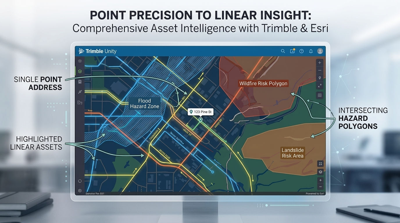
Comprehensive asset intelligence with Trimble and Esri puts GIS-centric data front and center at every stage of your project.
When a permitting system relies strictly on a text-based address or a basic XY coordinate drawn from a parcel centroid, it treats the real world as a series of isolated dots on a screen. This "point-address-only" trap assumes everything of interest happens at a single, static location. But infrastructure doesn't exist in dots. It exists in complex lines, shapes, boundaries, and networks.
When your system can't see those spatial relationships natively, the "bureaucratic villain" rears its head, creating serious real-world issues:
The compliance gap: Manual reviews and disconnected maps expose agencies to massive oversight errors. Nationally, local governments face an average of $1 million in annual fines and legal liabilities due to permitting compliance failures. If a permit is accidentally issued over a protected wetland or a hazard zone because the reviewer missed a map layer, the liability falls squarely on the agency.
The revenue bleed: When major commercial redevelopments or property improvements fail to link directly with the tax parcel layer, the data fails to reach the assessor’s office. Construction value evaporates into thin air, permanently shrinking the municipal tax base.
Public outcry and community pressure: In an era where rising populations demand rapid deployments of housing, broadband, and clean energy, a delayed permit is an economic throttle. When projects stall because of siloed data, public trust erodes, developers take their capital to more agile jurisdictions and community pressure mounts on city leadership.
You cannot solve modern, multi-dimensional spatial problems with non-spatial software.
Beyond the coordinate: Points, lines and polygons
This is where the distinction between being merely "GIS-interfaced" and truly GIS-centric becomes an operational game-changer.
Any software vendor can write an API that drops a pin on an XY point from a parcel centroid. But true GIS-centricity, the architectural core of Trimble Unity Permit (formerly Cityworks PLL), means the permit case lives natively inside the Esri ArcGIS database. There is no sync, no duplicate database and no data translation layer.
Why does this architectural difference matter to a public works director, a GIS manager, or a city planner? Because it allows you to tie a permit, license or inspection directly to any point, line or polygon asset in your GIS.
When your permitting workflows speak the exact same spatial language as your infrastructure asset registry, the boundary between community planning and public works completely disappears. Consider how this transforms advanced, real-world municipal workflows:
1. Complex spatial splitting and merging
When a developer buys a massive agricultural plot and splits it into a 50-lot residential subdivision, traditional address-centric systems break down. They cannot track the historical permitting lineage because the original address no longer exists.
A GIS-centric system natively tracks the evolution of the polygons. It automatically carries over easements, environmental restrictions and historical compliance records from the parent parcel to the newly created child parcels.
2. Navigating land splits and subdivisions
When a developer buys a massive agricultural plot and splits it into a 50-lot residential subdivision, traditional address-centric systems break down completely. Once the old address is retired, the historical permitting records associated with it become "orphaned" data.
A GIS-centric system solves this by leveraging the spatial lineage of the land. Because Trimble Unity Permit is built natively on ArcGIS, historical permits remain anchored to the parent record. Even after ArcGIS Parcel Fabric retires the parent parcel and generates new active child parcel IDs with brand-new unique identifiers.
Furthermore, because environmental constraints, easements, and zoning restrictions exist as independent, physical layers in your GIS, rather than just text attributes on a single parcel record, any new permit applied to a newly created child parcel is instantly validated against those spatial boundaries. You never lose the thread of historical compliance, even when the property boundaries shift under your feet.
3. Linear asset integration
If a contractor applies for a right-of-way (ROW) permit to excavate a street, a GIS-centric system doesn't just look at the street address. It looks at the actual linear assets: the water mains, the storm lines, the fiber conduits running under that specific segment of asphalt.
Because it knows the exact line geometry, it instantly flags conflicts with scheduled public capital improvement projects (CIP). This native intelligence prevents the classic municipal nightmare of cutting into a road that public works just resurfaced the previous week.
The launchpad for tomorrow: AI and digital twins
When you implement a truly GIS-centric permitting framework, you aren't just solving today's backlog; you are building the foundation for the next generation of digital governance.
There is an immense amount of buzz surrounding artificial intelligence (AI) and 3D digital twins in industry right now. But AI is only as good as the data feeding it. If your permitting records are locked away in flat text databases, they represent "dark data" completely invisible to advanced spatial algorithms.
Because the Trimble ecosystem can help clients capture highly accurate survey and GIS data allowing that data to be leveraged by Trimble Unity Permit workflows. Tying a permit to a spatial GIS asset, it delivers a data foundation that is immediately ready for advanced innovation:
Predictive AI: Machine learning models can analyze years of geographically anchored permit data to automatically forecast urban growth corridors, model future traffic congestion patterns, and predict utility capacity bottlenecks before they manifest in the real world.
Living digital twins: This continuous stream of real-time spatial permit data acts as the living, breathing pulse of a city’s geospatial 3D digital twin, allowing leadership to visualize changes to the built environment as they happen.
By putting permitting on the asset in the map, you unleash the throttle of economic growth.
Let's fast-track the future together
The communities that win the economic development contest of the next decade will be those that treat permitting not as a slow, paper-bound regulatory hurdle, but as a strategic catalyst driven by location intelligence.
If you are ready to stop looking at your community through a text box and start unlocking the true power of your spatial data, the teams at Trimble and Esri are here to show you the way. Our 25+ year partnership is built on providing the stability, longevity and innovation your enterprise systems require.
Learn more about GIS-centric permitting powered by Trimble Unity Permit and Esri ArcGIS.
Let’s stop digitizing paper. Let’s start mapping progress.


