Organizing, managing, and maintaining public assets and utilizing infrastructure data is no simple task. Utility organizations and local governments often send out surveyors to physically inspect things like pavement condition, markings, lighting, signage, trees, and vegetation, as well as street furniture and traffic operations. Onsite visits are costly and time-consuming and require in-person data collection, which can leave room for error and cause communication silos.
Nearmap helps eliminate data silos and replaces the need for onsite surveys by providing remote access to current geospatial aerial imagery. This gives organizations greater contextual understanding of asset locations, conditions, and attributed data all from the comfort of a remote workstation. Additionally, Nearmap AI automates the digitization process of impervious surface data, which simplifies an otherwise time-consuming workflow.
Using Nearmap in conjunction with Trimble Cityworks and Esri ArcGIS offers a highly scalable and efficient solution to managing and obtaining accurate asset data in a high-resolution aerial image format. Here are three ways that organizations can leverage Nearmap to enhance their asset management workflows.
Integrate Nearmap with ArcGIS
Integrating Nearmap with ArcGIS gives public works departments the ability to monitor infrastructure such as streets, bridges, tunnels, etc., without having to perform physical inspections or manual data entry, while also supporting quality assurance and quality control scoring.
Changes in assets can be remotely detected and viewed in a historic context within Cityworks and ArcGIS. Nearmap U.S. Vertical Imagery—available on Esri Marketplace—streams Nearmap content as a tiled service directly into any Esri environment and serves as a high-resolution map for tracking as set conditions.
Here’s how to do it:
Step 1 – You must have a current Nearmap subscription to view Nearmap imagery. Once your Nearmap account is provisioned, Nearmap has a complimentary ArcGIS Integration product. Once the user requests access to the Nearmap U.S. Vertical Imagery item through Esri Marketplace, they will be able to leverage this item in any Esri ArcGIS environment.
Step 2 – After access is granted, the admin user may share this item with groups inside the organization for desktop and webmap integration through ArcGIS Online.
Step 3 – Simply search for “Nearmap US Vertical Imagery” inside your ArcGIS Organization and add the Item to your map environment as a layer.
Step 4 – Click the three small dots on the service and select Image Filter to view different dates of capture for your area of interest.
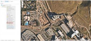
The menu under “Nearmap US Vertical Imagery” allows users to filter imagery by capture date.
Use Nearmap AI to automate impervious surface data
GIS professionals must digitize and create vector data containing attributes of surface features like asphalt, concrete, and lawn grass. This process is time-consuming and detail-oriented, given the GIS user must effectively trace and create a feature that represents the surface they need to identify and add information to.
Nearmap has an artificial intelligence content offering that can be used to automate this digitization process. Nearmap’s AI automatically labels features as raster features using confidence levels for unique pixel values. From there, rasters are automatically converted to vector polygons, significantly reducing the amount of time spent on the digitization of surface data.
The automated attributes contain information about the size of the polygon area (in square feet), the capture date, confidence levels in labeling the polygon, and location.
Here’s how to do it:
Step 1 – Ingest Nearmap high-resolution aerial imagery using the Esri Marketplace Item as a webmap in ArcGIS Online to be consumed by Trimble Cityworks.
Step 2 – Ingest vectorized AI features into the same webmap so the user now has high-resolution imagery matching the date of the captured AI vector features.
Step 3 – Ingest the ArcGIS Online webmap into Trimble Cityworks Designer to gain location intelligence on your site.
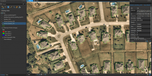
Nearmap’s AI automates the labeling of features, as shown by the vector polygons outlining the houses in this image.
Manage assets using 3D GIS
Nearmap supports organizations that are leveraging 3D data to manage their assets. Utilities and local governments can quickly determine the z-value of their assets, acquire asset height characteristics, and establish up-to-date 3D models from Nearmap’s frequently captured 3D derivative products.
Quickly rectify your area of interest using Nearmap’s 3D textured mesh scene layer package or create 3D vector buildings in level of detail 2 (LOD2) using Nearmap’s DEM, DSM, and AI Building footprints. Trimble Cityworks, Esri, and Nearmap have made it simple to transition your 2D asset data to a 3D environment.
Step 1 – In ArcGIS Pro, add Nearmap’s 3D textured mesh slpk to a local scene or create your LOD2 buildings. Then Share as Web Scene.
Step 2 – Navigate to your Trimble Cityworks Designer, select Add Map Scene and upload your new web scene URL.
Step 3 – Access your 3D assets within the web scene view to create work orders and manage your asset data in 3D.
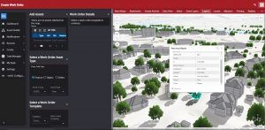
Assets being managed within a web scene view of a 3D GIS map.
The workflows outlined in this article are designed to help organizations leverage Nearmap’s solutions and integrate them into Trimble Cityworks and ArcGIS. Nearmap gives users access to frequently updated aerial data and location analytics, as well as automated feature extraction, which ultimately saves time, decreases the need for on-site inspections, and streamlines workflows.


