
Whether it is flipping a lightswitch, turning on a water faucet, or traveling on a road, public infrastructure has a direct impact on our everyday lives. Sustainable and efficient infrastructure has the potential to connect communities, promote health, foster equity, and enrich quality of life on an individual level. In the United States, the reality is that much of the country’s public works are rapidly aging— becoming outdated and, in some cases, unsafe. For years, U.S. infrastructure has been largely underfunded, leaving public works and utility organizations to grapple with the task of maintaining their communities’ aging assets while also staying within budget constraints.
If you are one of many asset managers in the U.S. feeling overburdened by the amount of infrastructural upkeep that needs to be done, you have likely worked day-in and day-out to ensure that your public assets are well maintained to the best of your ability. With new funding opportunities on the horizon, you may also be in luck.
New opportunities on the horizon
This past year, focus on Capitol Hill in Washington, D.C., has shifted toward infrastructure improvement programs. A handful of new bills and packages have been proposed and passed and aim to increase funding for a wide spectrum of infrastructural improvements in the U.S., ranging from water and wastewater to roads and electricity. These bills and packages have the potential to free up billions of dollars of federal funding and create opportunities for local governments and utilities to bring their community services up to date.

One issue in particular that is brought up in almost every piece of infrastructure policy is the need to update water infrastructure—namely the inventory, management, and removal of lead piping and service lines.
It is well known that lead is very harmful to human health and poses an extreme safety hazard for communities where they are present. In fact, the Natural Resources Defense Council, an environmental group, estimates that there could be as many as 12.8 million lead services lines in the U.S. that need replacing. It is only a matter of time before cities across the country are required to inventory, inspect, and remove their lead pipes and service lines.
Cities like Flint and Dearborn, Michigan, have already begun their lead abatement process. Here’s how Trimble Cityworks and Esri ArcGIS are helping them inventory, inspect, and remove lead piping and service lines.
Inventory
The first step of planning for any infrastructure project is knowing where your assets are located and which ones need to be upgraded. As Andrew Murray, GISP for DLZ Michigan, Inc. who works on behalf of the City of Flint puts it, “The actual physical execution of replacement is one part of the process, but the documentation portion of lead removal is just as important.” One of the difficulties many cities run into when starting the lead removal process is a lack of information concerning the location of lead service lines. A large portion of water infrastructure in the U.S. was installed long before laws required detailed material and location records.
To fill this data gap, Flint used lead service line inventory data that the University of Michigan-Flint compiled from digitized tap cards and historic parcel records, and then mapped out and visualized in ArcGIS. A similar inventory process has been adopted by the City of Dearborn. In order to comply with state mandates, the city has taken it upon itself to sift through vast amounts of tap card and historic infrastructure data to locate potential lead service lines.
“The whole process for maintaining a digital inventory was new and we had to start from the ground up,” says Eric Roggow, the Trimble Cityworks administrator for the City of Dearborn. “It was a difficult task to undertake. Pipe material data from the time of installation was often unreliable or totally absent and this data hadn’t been recorded digitally.” Dearborn was able to work through this process to organize a preliminary inventory of lead service lines in their community.
Similar to Flint, Dearborn’s inventory data is constantly being updated in ArcGIS as the lead abatement process is being completed. This ensures that a GIS-centric system of record is being created not only for present replacement efforts, but for future maintenance activities. “Our inventory is constantly evolving and getting updated. So when someone goes out to do an inspection, they can see in Trimble Cityworks what material we have previously documented for a particular address,” says Roggow.
Dearborn has also created a way for the community to get involved in the lead abatement and inventory process. The city has set up a survey using Esri's Survey123 and ArcGIS Online that allows residents to report what type of service line materials are used in their homes. Around 300 hundred of these surveys have already been submitted to the city, contributing valuable data to the city’s water infrastructure material inventory.
Inspections
The inventory data in ArcGIS provides a foundation for the inspection process, which consists of in-person assessments by city crews and contractors. At the start of their inspection process, Flint was using a legacy asset management system and paper spreadsheets to keep track of inspection data.
“Everything was disorganized and stored on various hard drives, flash drives, and printed documents,” says Terry Biederman, vice president of DLZ Michigan, Inc. Flint eventually implemented Trimble Cityworks AMS to organize and maintain their inspection and restoration data and workflows. “It was great to have everything in one place where all of our data was standardized, searchable, and easily accessible.”
Inspection work orders were created in Trimble Cityworks AMS and based off of the location information from the inventory GIS data. Contractors performed their inspections, and all observations and data were logged in custom Trimble Cityworks inspection templates. These inspection templates included various data fields where observations were recorded, pictures were taken, and it was determined whether a restoration or replacement was needed.
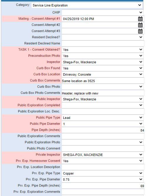
A service line exploration form with custom fields: used by the city of Flint, Michigan
A similar process within Trimble Cityworks and ArcGIS has greatly enhanced Dearborn’s inspection efforts, which was originally done by use of paper spreadsheets and digital cameras. “Trimble Cityworks streamlined the inspection process by helping us organize our inspection data and images and making us more time efficient. We no longer have to constantly update and keep track of various spreadsheets,” says Roggow.
The City of Dearborn now uses Trimble Cityworks and ArcGIS in both field and office settings to assist with data collection and organization in the inventory, inspection, and abatement process. Dearborn currently collects service line material data in the course of their water main replacement projects. Inspectors are sent out to conduct an inventory of pipes and service lines in the area where a water main replacement is taking place. For areas where water mains were already replaced, inspections are also conducted and recorded in Trimble Cityworks.
Replacement
Once the inventory and inspections were complete, Flint used Trimble Cityworks to transfer lead pipe replacement work to contractors by creating a restoration work order. This ensured that the full lead removal process was smooth and fostered communication between city crews and contractors. Through this process and the use of Trimble Cityworks and ArcGIS, Flint was able to update their water infrastructure and ensure the safety of their community by fulfilling approximately 8,900 inspection and replacement work orders over the course of nine months.
In the City of Dearborn, lead lines identified during water main replacement projects are removed and replaced with copper lines by contractors. Other replacement projects, completed by city crews, are fully managed in Trimble Cityworks. When lead is discovered during the inspection process, a child work order is created in Trimble Cityworks to kick off the service line replacement project. City crews document equipment, labor, and material in Trimble Cityworks in order to keep track of the full abatement process.
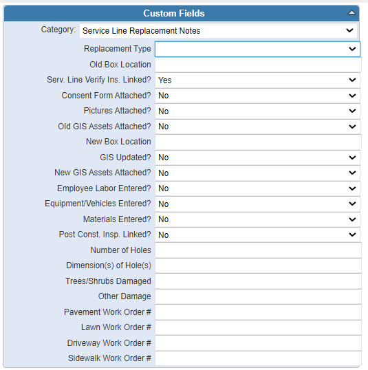
A service line replacement work order with custom fields; used by the city of Dearborn, Michigan.
After lead service lines are replaced, water quality sampling is documented in Trimble Cityworks. This ensures the ongoing health and safety of the community.
Dearborn also uses the GIS information and Trimble Cityworks data to create reports for the Michigan Department of Environment, Great Lakes, and Energy (EGLE). This allows the city to share with the State of Michigan the efforts that they have put into the lead abatement process and comply with state mandates.
“We are required to replace all lead in the city within the next 20 years,” says Roggow. However, Roggow is confident in the city’s lead removal program and the tools that they have adopted. “We have good plans in place to make sure we accomplish that before the deadline.”
Looking Ahead
With an increased focus on infrastructure revitalization in the U.S., it is likely that many local government and utility organizations will be following in the footsteps of Flint and Dearborn by setting up their own lead abatement programs. Trimble Cityworks can not only help you organize, manage, and maintain your infrastructure throughout its entire lifecycle, it can also help you plan and execute public works projects, such as removing lead from your water system. The main goal of infrastructure investment and projects is to ensure that public assets are safe, sustainable, efficient, and foster equity for years to come.


